Workshops
-
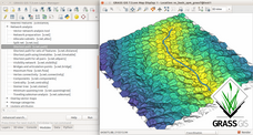
Introduction to GRASS GIS with network analysis
V. Petras. Introduction to GRASS GIS with network analysis. Geospatial Studio at North Carolina State University. 1 hour. Recording on YouTube, HTML
GRASS GIS covers geospatial analysis from hydrology through remote sensing to network analysis. Make your first steps in GRASS GIS in Geospatial Studio. Come few minutes sooner if you don't have GRASS GIS installed. After the introduction, there will be time to try your own data with GRASS GIS.
-
Using GRASS GIS through Python and tangible interfaces
A. Petrasova, V. Petras, B. Harmon, H. Mitasova FOSS4G North America 2016, Raleigh, USA. Half day.
Come and learn about scripting, graphical and tangible (!) interfaces for GRASS GIS, the powerful desktop GIS and geoprocessing backend. We will start with the Python interface and finish with Tangible Landscape, a new tangible interface for GRASS GIS. Python is the primary scripting language for GRASS GIS. We will demonstrate how to use Python to automate your geoprocessing workflows with GRASS GIS modules and develop custom algorithms using a Pythonic interface to access low level GRASS GIS library functions. We will also review several tips and tricks for parallelization. Tangible Landscape is an example of how the GRASS GIS Python API can be used to build new, cutting edge tools and advanced applications. Tangible Landscape is a collaborative 3D sketching tool which couples a 3D scanner, a projector and a physical 3D model with GRASS GIS. The workshop will be a truly hands-on experience – you will play with Tangible Landscape, using your hands to shape a sand model and drive geospatial processes. This workshop is open to beginners. There will be opportunities, however, to discuss more advanced topics tailored to individual interests in breakout sessions during the workshop. Participants should bring laptops with GRASS GIS 7 and their favorite Python editor. Beginners may consider using the latest OSGeo-Live virtual machine.
-
Workshop on urban growth modeling with FUTURES
A. Petrasova, V. Petras, D. Van Berkel, M. Dorning, B. Pickard, R. Meentemeyer, H. Mitasova. US-IALE 2016 Annual Meeting. 1 day.
Spatial patterns of land use change due to urbanization and its impact on the landscape is the subject of ongoing research. Urban growth scenario simulation is a powerful tool for exploring these impacts and empowering planners to make informed decisions. In this workshop, we will introduce FUTURES (FUTure Urban - Regional Environment Simulation) - a patch-based, stochastic, multi-level land change modeling framework implemented in GRASS GIS 7. FUTURES is a fully open source land change modeling framework that accommodates multilevel drivers of land change across a heterogenous region. Participants will learn the concepts, input data and general workflow of the model and get the chance to simulate emerging landscape spatial structure in urbanizing regions of North Carolina. We will start with hands-on exercises in GRASS GIS, a free and open source scientific platform for geoprocessing. We will cover spatial processing and analyses of urban growth predictors such as landscape topography, hydrography, cost and proximity, followed by introduction to spatio-temporal data handling and visualization. We will also demonstrate how GRASS GIS, Python and R interfaces can be leveraged for developing workflows, including tips and tricks for parallelization when working with ‘big data’. Participants will then run urban simulations using FUTURES with different possible population and spatial planning scenarios. This workshop is a great introduction to GRASS GIS including the unique tools available in GRASS GIS Addons repository.
-
Spatio-temporal data in GRASS GIS
V. Petras. North Carolina State University. 1 hour.
-
LaTeX introduction
V. Petras. North Carolina State University. Invited workshop for class. Introduction to artile document class using Overlef. 1.5 hours. [Screencast with sound]
-
Python interface to GRASS GIS
V. Petras. North Carolina State University. Invited workshop for class. Using IPython Notebook either remotely on a server or in OSGeo-Live. 1.5 hours. [Screencast with sound]
-
How to write a Python GRASS GIS 7 addon
P. Zambelli, M. Neteler, L. Delucchi, V. Petras, A. Petrasova FOSS4G Europe 2015. Half day. Also tested beforehand at North Carolina State University.
GRASS GIS is a leading software in analysis of geodata, it offers more than 400 modules in its core version plus many addons (i.e., user contributed modules). But what if the tool you are looking for is not present in GRASS GIS? So, simply create your own, we will show you how to do that in this workshop. In GRASS GIS 7, Python is the default language for creating addons. There are two main Python libraries included in GRASS GIS. Python Scripting Library allows you to perform analysis and compute new data by chaining existing modules to create your own workflow. With PyGRASS library wrapping the C functions, you can create new data sets (vector and raster) directly through Python calls, increasing considerably the power and performance of your scripts. You can conveniently mix both GRASS Python libraries with other Python libraries like NumPy, or SciPy. In this workshop, we will guide you through the basic steps of writing your own Python scripts, starting with calling and chaining GRASS GIS modules, followed by a more pythonic experience when using PyGRASS to access and modify your data directly. You will then upgrade your script into an addon by defining a simple interface to enable automatically generated GUI. The next part of workshop will look into more advanced usage of GRASS GIS 7 capabilities, including Python spatio-temporal API to handle time series in your addons, creating your own toolbox with your newly developed addons and finally, introducing the new testing framework you should use as a responsible person to make sure your addons are in great shape. Don't worry if we won't cover all the topics during the workshop, all materials will be accessible online and GRASS GIS community is always prepared to answer your questions!
-
Introduction to GRASS GIS
V. Petras. 1.5 hour.
Introduction to geospatial processing with GRASS GIS. The course covers basic control of the graphical user interface, invoking GRASS modules in different ways including scripting and various geospatial analysis.
-
Spatio-temporal data handling and visualization in GRASS GIS
V. Petras, A. Petrasova, H. Mitasova, M. Neteler. FOSS4G 2014, Portland, OR, USA. 4 hours. Also tested beforehand several times at North Carolina State University.
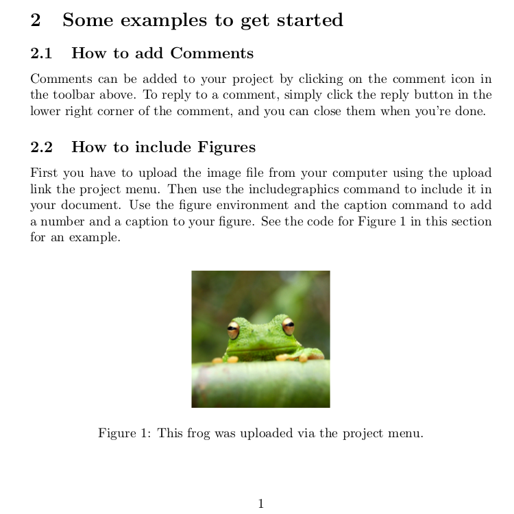
First, we will introduce you to GRASS GIS 7, including its spatio-temporal capabilities and you will learn how to manage and analyze geospatial data time series. Then, we will explore new tools for visualization of spatio-temporal data. You will create both 2D and 3D dynamic visualizations directly in GRASS GIS 7. Additionally, we will explain the Space Time Cube concept using various applications based on raster and vector data time series. You will learn to manage and visualize data in space time cubes (voxel models). No prior knowledge of GRASS GIS is necessary, we will cover the basics needed for the workshop. This workshop was created for FOSS4G 2014.
-

Git and GitHub workshop
V. Petras. 1.5 hour.
This workshop covers the differences between Git and GitHub and provides brief introduction to basic Git commands to help researchers start using it for their own projects.
-

Various smaller workshops
V. Petras. Several smaller workshops, usually about an hour and half.
About using GRASS GIS efficiently in the command line, how to program with GRASS GIS in Python, Bash and C/C++. and how to use OSGeo-Live. OSGeo-Live is a Linux distribution packed with open source geospatial software. I will try to introduce you to what's in there and how to use it. I may drift to some general Linux things as well. I also presented on writing tests and test suites for GRASS GIS and general C/C++ programming. Finally, I did introduction to Python and GRASS GIS in several classes.