Research
-
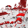
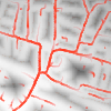
Point cloud data analysis
I focus on developing practical methods and software tools for processing large point clouds from lidar or structure from motion (UAV) data processing. My idea is to develop tools which will not only derive the information from the data, but tools which will be also able to work with other geospatial processing tools and will serve as a base for future algorithms.
-
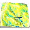
Rapidly changing landscape evolution analysis
I work on different tools for landscape evolution analysis with a focus one rapidly evolving coastal areas. I'm using a concept of space-time cube to represent and model space and time.
-
Publishing geospatial research in the open science way
I explore new ways how to share scientific results and methods in the field of geospatial sciences.
-
Geospatial software quality assessment
I work on methods and software tools for geospatial software quality assessment, which allows he and other scientists to test the proper functionality of various geospatial algorithms.
-
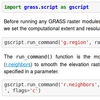
Environmental modeling in free and open source GIS
I pursue a topic of GIS-based environmental modeling because I consider GIS to be advantageous for different kinds of modeling, especially when different data needs to be combined. However, I don't think that just any GIS is such a great advantage. I actually think that only free and open source GIS can do the service to modelers well because of long-term sustainability, community support and most importantly complete openness and freedom. Consequently, I have created or improved several modeling tools in GRASS GIS where one can find many examples of environmental models and how they are maintained and improved over years.
-
Communicating research through visualizations online
I work on lightweight solutions for publishing maps and spatio-temporal visualizations for communicating research online using both web-based and desktop-based tools. The goal is to make sharing visualizations online as simple as it is to share a simple picture. The point is that this can even include a simple picture such as animated GIF if this is an sufficient solution to given task.
-
Enabling science through usage of free and open source software
I collaborate on free and open source software development, most notably, development of GRASS GIS. I believe that open source software is a crucial part of open and reproducible science and that providing my work as open source allows equal opportunities for all scientists around the world to use, critique, and further develop the results of my research.
-
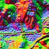
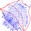
Exploratory visualizations spatial and spatio-temporal data
I'm interested in visualization tools which help scientist understand their data and derive meaning and results from them.